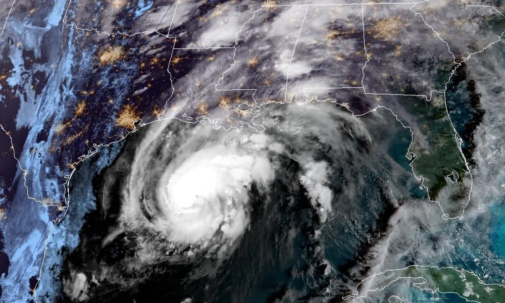
Zeta is continuing its path toward the Gulf Coast, and it is strengthening. Zeta is now a hurricane again and is forecast to be a category two hurricane when it comes ashore this evening.
“As expected, #Zeta is strengthening as it moves across the Gulf of Mexico,” the Baldwin County Emergency Management Agency warned. “The windfield extends nearly 150 miles and we will begin to see impacts such as tropical winds, rain, rip currents and dangerous surf, as well as storm surge in Baldwin County.”
Zeta currently has sustained winds of 85 mph. On its current course, it will make landfall along southeastern Louisiana or the Mississippi coast late this afternoon. It should move through Alabama tonight.
A Hurricane Warning is in effect for Morgan City, Louisiana, to the Mississippi-Alabama state line including Lake Pontchartrain, Lake Maurepas and metropolitan New Orleans.
According to the NOAA, hurricane conditions are expected there this afternoon, with tropical storm conditions beginning later this morning.
Preparations to protect life and property should be rushed to completion. Damaging winds, especially in gusts, will spread well inland across portions of southeastern Mississippi and southern Alabama this evening and tonight.
A Storm Surge Warning is in effect from the mouth of the Atchafalaya River to Navarre Florida including Lake Borgne, Lake Pontchartrain, Pensacola Bay and Mobile Bay.
“If you live in a low-lying area you should evacuate before dark on Wednesday evening to a safer place,” warned Congressman Bradley Byrne, addressing Mobile and Baldwin County residents. “If you live on higher ground in southwest Alabama please make your plans Wednesday to be wherever you plan to spend the night by dark Wednesday evening and do not leave until daylight Thursday as we will experience tropical storm force winds and 2-4 inches of rain which could cause flash flooding, downed trees or downed live power lines. This storm should pass through our area rapidly and be gone early Thursday. Let’s all pray that this is the last storm of this hurricane season.”
ABC 33/40 television meteorologist James Spann said on social media, “We will deal with periods of rain today with temperatures in the 70s; the main wind and rain associated directly with Zeta will come tonight, and there is potential for a high impact wind event for much of the state.”
Storm surge predictions have risen since yesterday. Under current forecasts, Zeta is expected to bring a storm surge of six to nine feet for Dauphin Island. The storm surge will be four to six feet in Mobile Bay, and three to five feet for the Baldwin County shore towns of Fort Morgan, Gulf Shores and Orange Beach to the Florida line.
Wind gusts in Mobile and Baldwin counties could be as much as 70 miles per hour. Isolated tornadoes are a possibility as this powerful storm system moves through the state of Alabama.
Because the storm is moving so fast, it should not produce as much torrential rain as a slower moving storm, reducing the flooding risk; however, that fast speed means that it won’t lose a lot of strength as it moves through the state, thus tropical storm winds could be experienced well inland.
Most of Alabama should get 1 to 3 inches of rain. The combination of heavy winds and heavy rains could weaken the root systems of trees meaning there is a possibility of losing power tonight. Citizens should check their emergency kits and make sure that they have flashlights, batteries, radios and fully charged phones in case they are needed tonight.
The Mobile County Emergency Management Agency is asking that people who live on the coast or in flood-prone areas to evacuate before tonight. Shelters have been set up in Mobile County including a medical needs shelter.
The Alabama Department of Agriculture and Industries has set up a shelter for livestock evacuating the area at the Alabama A&M Agribition Center in Huntsville.
Sandbags are available at the Baldwin County Commission office in Robertsdale. There is a limit of 25 bags per person while supplies last.
Alabama Gov. Kay Ivey has declared a state of emergency.
Baldwin, Mobile and Escambia Counties were declared a natural disaster area after Hurricane Sally slammed into the state last month. Many areas are still in the process of cleaning up from that storm.


