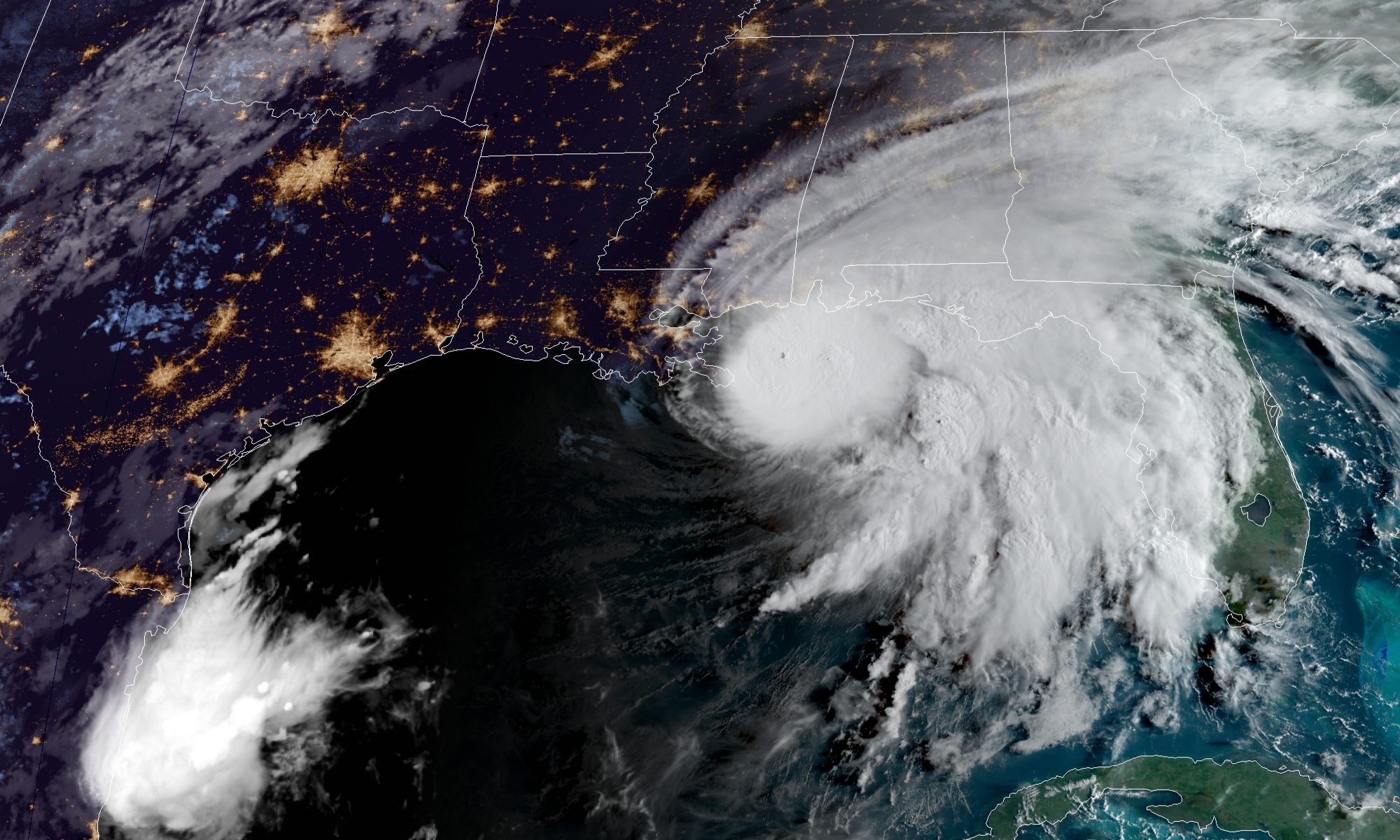
Tropical Storm Sally became Hurricane Sally on Monday, but it also slowed down. Just 24 hours ago the storm was expected to come ashore at 8 a.m. Tuesday but because of the hurricane’s slow speed, landfall is now not expected before Wednesday.
“This thing is basically moving slower than I can walk,” ABC 33/40 meteorologist James Spann said Tuesday morning.
The hurricane is practically stationary, and it weakened overnight from a category two to a category one hurricane. But its slow-moving nature is upping concerns that it could cause torrential rain and potentially historic flooding.
“The concern with this all along has not been the wind but the rain potential,” Spann said.
Sally is expected to be a slow moving system even as it approaches land, which means it will be a major rain event, producing 10 to 20 inches of rainfall with isolated amounts of 30 inches along and just inland of the central Gulf Coast — from the western Florida Panhandle to far southeastern Mississippi.
Life-threatening flash flooding is likely through Wednesday. In addition, this rainfall will lead to widespread moderate-to-major flooding on area rivers.
Hurricane #Sally is likely to produce extreme life-threatening flash flooding through Wed along and just inland of the central Gulf Coast from the western Florida Panhandle to far southeastern Mississippi. @NWSWPC expects 10-20" of rain, isolated 30"- historic flooding possible. pic.twitter.com/RPHVT0LR4F
— National Hurricane Center (@NHC_Atlantic) September 15, 2020
Sally currently has sustained winds of 85 mph and is located about 115 miles south of Biloxi, Mississippi. The storm weakened overnight due to a decline in sea surface temperature caused in part by its near-stationary positioning that led to a phenomenon called upwelling.
{{CODE1}}
Landfall is now expected to be near the Mississippi-Alabama border at category one strength with Alabama receiving the brunt of the hurricane’s more damaging eastern side. The path of the storm can change as this storm’s path has changed since Sunday. Hurricane-force winds, dangerous storm surge and flooding rainfall will occur over a large portion of Gulf Coast.
“It is still too early to determine where Sally’s center will move onshore given the uncertainty in the timing and location of sally’s northward turn near the central Gulf Coast,” the National Hurricane Center said Tuesday morning. “Users should not focus on the details of the official forecast track, since NHC’s average forecast error at 36 hours is around 60 miles, and dangerous storm surge, rainfall, and wind hazards will extend well away from the center.”
Here are the Key Messages for #Sally on Tuesday morning. The hurricane is expected to cause many life-threatening hazards, as detailed below. The latest NHC advisory is at https://t.co/tW4KeFW0gB and your local weather forecast is https://t.co/SiZo8ohZMN pic.twitter.com/Fi558tk15O
— National Hurricane Center (@NHC_Atlantic) September 15, 2020
A Storm Surge Warning is in effect for an area stretching from the mouth of the Mississippi River to the Okaloosa-Walton County Line in Florida. A Hurricane Warning is in effect for east of the mouth of the Pearl River to Navarre, Florida.
The combination of the dangerous storm surge and the tide will cause normally dry areas near the coast to flood. The water could reach 6 to 9 feet above ground level from the mouth of the Mississippi River to Dauphin Island including Lake Borgne and Mobile Bay. The storm surge from Dauphin Island to the Alabama-Florida border is forecast at 4 to 7 feet.
Sally is forecast to turn inland early Wednesday and move across the Southeast producing rainfall of 4 to 8 inches, with isolated maximum amounts of 12 inches, across portions of southeastern Mississippi, southern and central Alabama, northern Georgia and the western Carolinas.
Significant flash and urban flooding is likely, as well as widespread minor to moderate flooding on some rivers.
There is the possibility of a tornado or two Tuesday and Wednesday morning in coastal areas of the Florida Panhandle and Alabama. The tornado threat should increase and slowly spread inland the rest of today into Wednesday.
Due to likely life-threatening surf and rip current conditions Alabama Gov. Kay Ivey has closed all of Alabama’s beaches Monday at 3 p.m.
Rain will become widespread during the day Tuesday with the heavy rain mainly south of Interstate 20. A flash flood watch is in effect from I-20 south. Rain amounts across the central and southern counties of the state will range from 2 to 8 inches with the highest totals roughly around the I-85 corridor from Montgomery to Opelika.
Hurricane #Sally Forecast Changes: The axis of heaviest rainfall has shifted to the east along with the eastward adjustments in Sally's forecast track. Removed a few northern counties from the Flash Flood Watch. 🌧Flooding from tropical downpours remains the primary threat. #alwx pic.twitter.com/YUTPAQzARM
— NWS Birmingham (@NWSBirmingham) September 15, 2020
On Wednesday, winds of 15 to 30 miles per hour are likely over the southern two-thirds of the state. We do not expect widespread tree and power line damage or major power outages. A few isolated, brief tornadoes are possible south of a line from Mobile to Montgomery to Opelika with the higher probabilities across Southeast Alabama.
The rain is likely to end from west to east during the day Thursday.


